Research Article | | Peer-Reviewed

Urban Land Use and Particulate Matter Distribution During Winter: A Case Study of Pabna District Town, Bangladesh

Received: 29 June 2025     Accepted: 28 July 2025     Published: 9 September 2025
Views:       Downloads:
Abstract

Air pollution is a major public health concern in Bangladesh, contributing to significant respiratory and cardiovascular issues. The objective of this study is to monitor the Particulate Matters (PM1, PM2.5 & PM10) and Carbon Monoxide (CO) concentration based on different land use in Pabna district town. This study was conducted in 40 locations of Pabna district town, by using portable Air Quality Monitor, Indoor Outdoor Formaldehyde (HCHO) Detector (Model: DM106) and CO Meter (Model: AS8700A). It was found that, the average concentrations of PM1, PM2.5 & PM10 of 40 places in Pabna district town were 34.50, 57.02 and 73.43 µg/m3 respectively. The average concentration of PM2.5 and PM10 were found 2.28 and 1.49 times higher than World Health Organization (WHO) which is respectively. It is estimated that the average PM2.5 /PM10 was 77.63%, PM1 /PM2.5 was 60.46%. From the outcome of this research the studied land uses are arranged in descending order based on average concentration PM which follows as road intersection area > commercial area > mixed area > industrial area > residential area > sensitive area. Therefore, the findings underscore the urgent need for targeted air quality management strategies in Pabna district, particularly in high-pollution areas, to mitigate health risks associated with elevated particulate matter concentrations.

Published in Journal of Health and Environmental Research (Volume 11, Issue 3)
DOI 10.11648/j.jher.20251103.14
Page(s) 76-88
Creative Commons

This is an Open Access article, distributed under the terms of the Creative Commons Attribution 4.0 International License (http://creativecommons.org/licenses/by/4.0/), which permits unrestricted use, distribution and reproduction in any medium or format, provided the original work is properly cited.

Copyright

Copyright © The Author(s), 2025. Published by Science Publishing Group

Keywords

Particulate Matter, Gaseous Pollutants, Descriptive Statistic, Pabna District Town

1. Introduction
Air pollution is any chemical, physical, or biological substance that modifies the basic characteristics of the atmosphere and contaminates its interior or exterior surroundings . Approximately 7 million people worldwide lose their lives to air pollution every year; most of these deaths take place in low- and middle-income countries, and nine out of ten breathe air that is more polluted than what the World Health Organization considers safe . Air pollution is the leading environmental threat to public health worldwide, resulting in seven million premature deaths annually . It is closely linked to climate change, as the majority of major pollutants have origins that are shared with greenhouse gases, which negatively affect the climate. A World Bank estimate for 2019 states that the yearly cost of health damage caused by air pollution is $8.1 trillion, or 6.1% of global GDP . Hazardous pollutants like particulate matter, carbon monoxide, ozone layer, nitrogen dioxide, and sulfur dioxide are among the air pollutants that come from sources like home combustion, automobiles, industries, and forest fires. These pollutants can all lead to severe respiratory problems and other illnesses, which greatly increase the rates of illness and death . The majority of life years lost due to pollution (92.7%) are in Asia and Africa, with the US and Canada contributing for 4.2% of these losses. Particulate pollution, or PM2.5, is continuously the world's greatest external risk to human health, pollution is expected to shorten average life expectancy by 2.3 years worldwide . As per a report, non-communicable diseases like diabetes, lung cancer, heart disease, stroke, and chronic obstructive pulmonary disease (COPD) account for nearly 90% of the illness burden caused by air pollution. In 2021, air pollution accounted for 8.1 million fatalities worldwide, including those of children under five . PM are microscopic liquid and solid particles that are airborne and can be divided into two sizes: PM10, or particles less than 10 micrometers, and PM2.5, or particles smaller than 2.5 micrometers . PM2.5 poses a significant risk to human health due to its association with oxidative stress and inflammatory reactions in the respiratory system. It has also been connected to around 4 million deaths worldwide from cardiopulmonary disorders .
Dhaka was identified as the most polluted city, and Bangladesh was classified as the most polluted country with an annual average of PM2.5 of 79.9, which is about 15 times higher than the WHO PM2.5 yearly guideline . According to a study, the average PM2.5 concentration in Dhaka in 2023 was 2.96 times higher than the limit of the country's ambient air quality guidelines, at 103.67 µg/m3 . About 20% of all premature deaths in Bangladesh are attributed to air pollution, according to a World Bank report from 2023. The WHO Air Quality Guidelines are, on average, 150 percent higher than the levels of fine particulate matter (PM2.5) in Dhaka City's heavily developed and continuously trafficked areas which is roughly equivalent to smoking 1.7 cigarettes per day . A study that investigated the concentrations of PM2.5 and PM10 in 82 different locations in Dhaka found that pollution levels are greater than WHO limits in all land uses, and marked unfit vehicles, industries, and construction activities as key sources of air pollution . The Global Liveability Index for 2024, the top livable cities are dominated by those in Europe, Australia, and Canada due to factors such as healthcare, education, culture, environment, and infrastructure. However, Bangladesh ranked 168 in the Global Liveability Index out of 173 countries . The latest State of Global Air 2024 report highlights that air pollution causes the greatest disease burdens in South Asia and several African countries, with Bangladesh reporting over 235,000 air pollution-related fatalities in 2021 . In Dhaka, there has been a significant increase in the number of people diagnosed with respiratory disorders, having no severe prior health issues, suggesting a strong link between these ailments and exposure to polluted air .
However, in Bangladesh, localized data on pollutant concentrations and spatial distribution in semi-urban towns like Pabna remain limited. The objective of this study is to assess the spatial variation and concentration of particulate matter (PM1, PM2.5 & PM10) and carbon monoxide (CO) across 61 locations Pabna district town. Therefore, this study aims to bridge this knowledge gap by systematically assessing air quality levels across different land-use zones within Pabna, providing critical insights for policy-making and urban planning to mitigate the adverse effects of air pollution. The objectives of this study are: a) To identify the status of air pollution in Pabna District Town. b) To assess the relationship between land use and all parameters (PM1, PM2.5, PM10, and CO) and c) Geospatial mapping on the concentration of PM1, PM2.5, PM10, and CO.
2. Methodology
2.1. Study Area
Pabna District (rajshahi division) area 2376.13 sq km, located in between 23°48' and 24°21' north latitudes and in between 89°00' and 89°44' east longitudesh . The district is bounded by Natore and Sirajganj districts to the north; the Padma River, Rajbari, and Kushtia districts to the south; Manikganj and Sirajganj districts and the Jamuna River to the east; and the Padma River, Natore, and Kushtia districts to the west. A total of 40 locations were selected across the district for air quality monitoring, based on land use characteristics. These locations were categorized into seven land use types: sensitive, residential, mixed, commercial, road intersection, industrial, and village areas . Table 1 shows the description of land use and sample locations.
Table 1. Location and Land Use of Study.

S. N.

Land Use Type

Description

Number of Locations

1

Sensitive Area

Hospitals, clinics, schools, colleges, mosques, madrasas, temples, churches, administrative buildings

9

2

Residential Area

Primarily housing zones and residential neighborhoods

3

3

Mixed Area

Combination of markets, buildings, and main roads

6

4

Commercial Area

Business centers, shopping areas, and local markets

6

5

Road Intersection Aarea

Busy road junctions, bends, and high traffic zones

5

6

Industrial Area

Locations near factories and industrial establishments

11

Total

40

2.2. Instrument Description
Table 2. Instrument Description for Air Quality Monitor (Particulate Matter) & Carbon Monoxide (CO).

SL.

Parameters

Instrument

Model

1.

PM1, PM2.5, PM10, HCHO, TVOC, Temperature, Humidity

Air Quality Monitor, Indoor Outdoor Formaldehyde (HCHO) Detector

Model: DM106; B07SCM4YN3 (Saiko)

2.

Carbon Monoxide (CO)

Handheld Carbon Monoxide Meter

AS8700A (Smart Sensor / OEM)

2.3. Data Collection & Data Processing and Result Interpretation
As part of the survey, air quality was measured at 40 different locations across the Pabna district town area over the course of a single day using automated portable instruments, including a portable Air Quality Monitor, Indoor Outdoor Formaldehyde (HCHO) Detector (Model: DM106) and a Handheld Carbon Monoxide Meter. GPS data was recorded using an Android application called Garmin ETrex 10. At each location, four parameters PM1, PM2.5, PM10, and CO were measured at various times from morning to late evening to capture temporal variation. Data analysis was conducted using MS Excel, IBM SPSS V20, and MS Excel 2020. A range of visualizations, including graphs, tables, diagrams, and box-whisker plots, were generated to illustrate data distribution. Descriptive statistics were used to assess parameter dispersion, and ANOVA was performed to test statistical significance. ArcGIS 10.4.1 was used to develop concentration, with different color schemes applied to visually represent pollutant concentration levels across locations.
3. Analysis of Concentration of PM1, PM2.5, PM10 and CO
3.1. Status of Air Quality in Pabna District Town
The concentration of PM1, PM2.5 & PM10 in 7 different land use are shown in Figure 1(a), (b), (c), (d), (e), (f) and (g). Figure 1(a) illustrates the concentration (µg/m3) of PM1, PM2.5 & PM10 of some locations in sensitive areas in Pabna district town. These particular locations included administrative offices, educational institutes and mosques. As we could see, among these 9 sensitive places, three highly polluted places were in front of APS Office, Circuit House and besides Executive Engineers Office with PM concentration of 30, 50 and 64 µg/m3, 28.75, 49.25 and 61.75 µg/m3 and 28.5, 47.5 and 615 µg/m3 respectively and comparatively less polluted places were Chief Judicial Magistrate Court, Pabna Powroshova and Pabna Mental Hospital with PM2.5 concentration of 21, 41.5 and 41.25 µg/m3 respectively. It was also noted that the concentrations of PM2.5 and PM10 found in the most polluted place were 2.00 and 2.58 times higher than World Health Organization (WHO) which are 25 and 50 µg/ m3 respectively. The study estimated that in all sensitive areas, 78.03% of PM2.5 was present in PM10 and 60.19% of the PM1 was present in PM2.5.
Figure 1(b) shows the concentration (µg/m3) of PM1, PM2.5 & PM10 of some locations in mixed areas in Pabna district town. It has been found that out of 6 mixed places, three highly polluted places were Pabna Medical College, Public Works Division and Ataikul Road with PM concentration of 51.25, 85 and 108.75 µg/m3, 50.25, 81.5 and 105.75 µg/m3 and 43.5, 70.5 and 91.75 µg/m3 respectively and comparatively least polluted places were Public Library Pabna, Civil Surgeon Office Pabna and LGED PM concentration of 33, 44.25 and 50.25 µg/m3 respectively. It was also noted that the concentrations of PM2.5 and PM10 found in the most polluted places were 3.4 and 2.18 times higher than World Health Organization (WHO) which are 25 and 50 µg/m3 respectively. The study estimated that in all mixed areas, 77.75% of PM2.5 was present in PM10 and 60.24% of the PM1 was present in PM2.5.
Figure 1(c) shows the concentration (µg/m3) of PM1, PM2.5 & PM10 of some locations in residential areas in Pabna district town. It has been found that out of 3 residential places, the most polluted place was Himayetpur with PM concentration of 133.25, 54.5 and 71 µg/m3 respectively. Comparatively less polluted places were Dolilpur and Bus Stand Goli with PM2.5 concentration of 46.75 and 43.5 µg/m3 respectively. It was also noted that the concentrations of PM2.5 and PM10 found in the most polluted places were 2.18 and 1.42 times higher than World Health Organization (WHO) which are 25 and 50 µg/m3 respectively. The study estimated that the ratio of PM2.5 /PM10 was 77.63%. It was also found that 60.34% of PM1 mass was present in PM2.5.
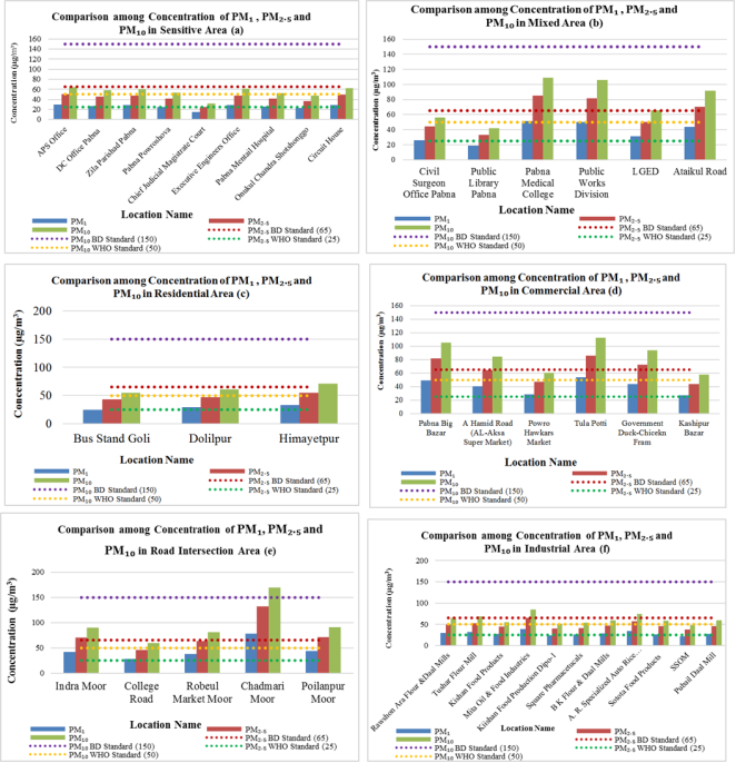
Figure 1. Comparison among average Concentration of PM1, PM2.5 & PM10 in Different Land Use.
Figure 1(d) shows the concentration (µg/m3) of PM1, PM2.5 & PM10 of some locations in commercial areas in Pabna district town. It has been found that out of 6 commercial places, three highly polluted places were near Tula Potti, Pabna Big Bazar and Government Duck-Chicken Fram with PM concentration of 54, 85.5 and 112.25 µg/m3, 49.25, 81.5 and 105 µg/m3 and 44, 72.5 and 93.75 µg/m3 respectively and comparatively less polluted places were Kashipur Bazar, Powro Hawkars Market and A Hamid Road (AL-Aksa Super Market) with PM concentration of 27.5, 44 and 58 µg/m3, 28.25, 47.25 and 60.75 µg/m3 and 40.75, 64.5 and 84.5 µg/m3 respectively. It was also observed that the concentrations of PM2.5 and PM10 found in the most polluted places were 3.42 and 2.25 times higher than World Health Organization (WHO) which are 25 and 50 µg/m3 respectively. The study estimated that the ratio of PM2.5/PM10 was 76.85%. It was also found that 61.62% of PM1 mass was present in PM2.5.
Figure 1(e) demonstrates the concentration (µg/m3) of PM1, PM2.5 & PM10 of some locations in road intersection areas in Pabna district town. It has been found that out of 5 road intersection places, three highly polluted places were Chadmari Moor, Indra Moor and Poilanpur Moor with PM concentration of 78.25, 132.25 and 169 µg/m3, 41.5, 70.5 and 90 µg/m3, 43.5, 71 and 90.5 µg/m3 respectively and relatively less polluted places were College Road, Robeul Market Moor Academy with PM concentration of 28.25, 46.25 and 60 µg/m3 and 37.75, 63 and 81 µg/m3 respectively. It was also observed that the concentrations of PM2.5 and PM10 found in the most polluted places were 5.29 and 3.38 times higher than World Health Organization (WHO) which are 25 and 50 µg/m3 respectively. The study estimated that the ratio of PM2.5/PM10 was 77.98%. It was also found that 60.06% of PM1 mass was present in PM2.5.
Figure 1(f) shows the concentration (µg/m3) of PM1, PM2.5 & PM10 of some locations in industrial locations in Pabna district town. It has been found that out of 11 industrial places, three highly polluted places are in Mita Oil & Food Industries, A. R. Specialized Auto Rice Mills and Tushar Flour Mill with PM concentration of 39.5, 65.5 and 84.25 µg/m3, 34.5, 57.75 and 74.25 µg/m3 and 32, 53.25 and 68.75 µg/m3 respectively and comparatively less polluted places were SSOM, Kiishan Food Production Dipo-1 and Square Pharmaceuticals with PM2.5 concentration of 38.25, 40.25 and 41 µg/m3 respectively. It was also observed that the concentrations of PM2.5 and PM10 found in the most polluted places were 2.62 and 1.68 times higher than World Health Organization (WHO) which are 25 and 50 µg/m3 respectively. The study estimated that the ratio of PM2.5/PM10 was 78.00%. It was also found that 60.12% of PM1 mass was present in PM2.5.
3.2. Comparison of Average Concentration of CO of Different Land Use
Figure 2 illustrates a comparison of average concentration of CO among seven lands use in Pabna district town. The graph shows that the average of CO was found to be highest in the road intersection area (20 ppm) followed by commercial area (15 ppm) and industrial area (12.73) which were higher than the standard level. It is harmful for the living organism if anyone stays for long time in that concentration. The concentration of CO in the most polluted area was 2.22 times higher than Bangladesh National Ambient Air Quality Standards (NAAQS) level which is 9 ppm (8-hour) respectively. The average concentration of CO was found to be relatively lower sensitive area, residential area and mixed area where the concentration did not exceed the standard level. Due to one sample collected area in village area the concentration is not presented here.
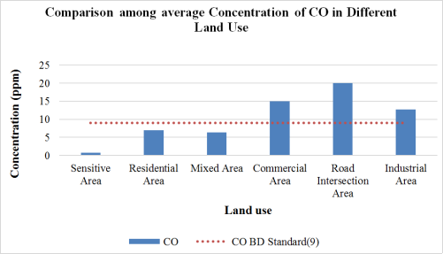
Figure 2. Comparison among average Concentration of CO in Different Land Use.
3.3. Dispersion of PM1, PM2.5, PM10 and CO
Table 3. Descriptive Statistics for PM1, PM2.5, PM10 and CO.

PM1

S. N.

Land Use

NoL

Range (µg/m3)

Mean (µg/m3)

Std. Deviation (µg/m3)

Coefficient of Variation (%)

1

Sensitive Area

9

15.25

25.64

4.65

18.12

2

Mixed Area

6

32.50

36.83

13.47

36.58

3

Residential Area

3

8.50

29.17

4.26

14.61

4

Road Intersection Area

5

50.00

45.85

19.04

41.52

5

Commercial Area

6

26.50

40.63

10.86

26.74

6

Industrial Area

11

17.50

28.89

4.93

17.08

PM2.5

S. N.

Land Use

NoL

Range (µg/m3)

Mean (µg/m3)

Std. Deviation (µg/m3)

Coefficient of Variation (%)

1

Sensitive Area

9

25.00

42.61

7.88

18.49

2

Mixed Area

6

52.00

60.75

21.29

35.04

3

Residential Area

3

11.00

48.25

5.65

11.71

4

Road Intersection Area

5

86.00

76.60

32.68

42.66

5

Commercial Area

6

41.50

65.88

17.32

26.30

6

Industrial Area

11

27.25

48.05

8.11

16.88

PM10

S. N.

Land Use

NoL

Range (µg/m3)

Mean (µg/m3)

Std. Deviation (µg/m3)

Coefficient of Variation (%)

1

Sensitive Area

9

32.00

54.58

9.92

18.18

2

Mixed Area

6

67.00

78.29

27.74

35.43

3

Residential Area

3

16.50

62.25

8.30

13.33

4

Road Intersection Area

5

109.00

98.10

41.52

42.32

5

Commercial Area

6

54.25

85.71

22.51

26.26

6

Industrial Area

11

36.25

61.66

10.70

17.36

The descriptive statistics for PM1, PM2.5, and PM10 across seven land use types show that the road intersection area consistently had the highest pollution levels in Table 3. For PM1, the maximum concentration was 78.25 µg/m3, with a mean of 45.85 µg/m3, standard deviation of 19.04 µg/m3, and coefficient of variation (CV) of 41.61%. In contrast, the sensitive area had the lowest mean (25.64 µg/m3) and minimum value (14.75 µg/m3). For PM2.5, road intersections again recorded the highest values: maximum of 132.25 µg/m3, mean of 76.60 µg/m3, standard deviation of 32.68 µg/m3, and CV of 42.66%. The lowest mean was in the sensitive area (42.61 µg/m3), and the lowest CV was in the village area (12.22%). Regarding PM10, the road intersection area had a maximum of 169.00 µg/m3, mean of 98.10 µg/m3, standard deviation of 41.52 µg/m3, and CV of 42.32%. The sensitive area recorded the lowest mean (54.58 µg/m3), and the residential area had the lowest CV (13.33%). These results highlight significantly higher particulate matter concentrations and variability in road intersections, while residential and sensitive areas show relatively lower and more stable pollution levels.
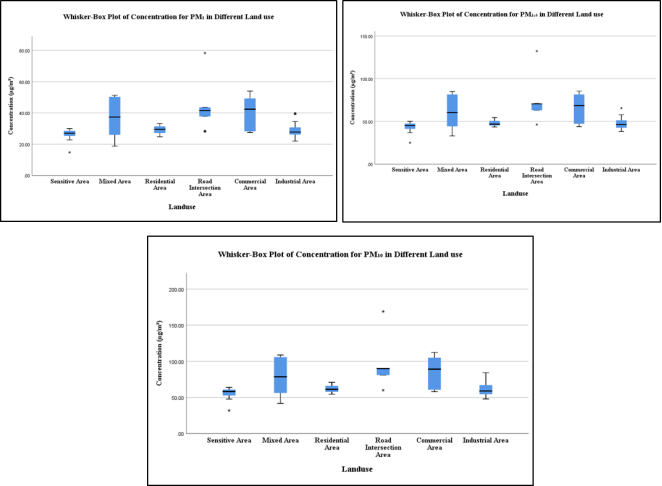
Figure 3. Whisker Box Plot of the Concentration of PM1, PM2.5 & PM10 in Different Land use.
The box-whisker plots for PM1, PM2.5, and PM10 across seven land use types illustrate variations in concentration, dispersion, and outliers in Figure 3(a), (b) and (c). In all three pollutants, the mixed area showed the highest dispersion, with positive skewness in PM2.5 and PM10, and normal skewness in PM1. Moreover, Commercial areas showed relatively high dispersion, with a negative skewness. A similar pattern of dispersion and skewness was observed in the Netrokona district . Road intersection and industrial areas exhibited moderate dispersion, each with two and one outlier(s), respectively primarily due to heavy traffic (e.g., Chadmari Moor) or industrial activity (e.g., Mita Oil & Food Industries). Residential and sensitive areas had more compact concentrations: residential areas with positive skewness, and sensitive areas with negative skewness, though one outlier was found near the Chief Judicial Magistrate Court, likely due to reduced dust levels. The plots collectively highlight significant spatial variation and pollution sources across land use types.
3.4. Dispersion of CO
The following Table 4 shows the descriptive statistics for CO of the seven land uses studied. The highest ranges were found in road intersection area (37 ppm) and the lowest ranges was found in residential areas (4 ppm). Among all those land uses the minimum concentration (0 ppm) was seen in all of those zones except residential area (5 ppm) and maximum concentration was seen in road intersection area (37 ppm). The highest mean value of CO was found in road intersection area (20 ppm) and lowest mean found in sensitive area (0.78 ppm). It was observed that the highest coefficient of Variation was found in sensitive area (300.00%) and the least variation was found in residential area which was 28.57%.
Table 4. Descriptive Statistics for CO.

SI No

Land Use

Number of locations

Range (ppm)

Min. (ppm)

Max. (ppm)

Mean (ppm)

Std. Deviation (ppm)

Coefficient of Variation (%)

1

Sensitive Area

9

7.00

0.00

7.00

0.78

2.33

300.00

2

Mixed Area

6

15.00

0.00

15.00

6.33

5.89

92.97

3

Residential Area

3

4.00

5.00

9.00

7.00

2.00

28.57

4

Road Intersection Area

5

37.00

0.00

37.00

20.00

15.72

78.58

5

Commercial Area

6

33.00

0.00

33.00

15.00

11.85

78.99

6

Industrial Area

11

31.00

0.00

31.00

12.73

9.26

72.79

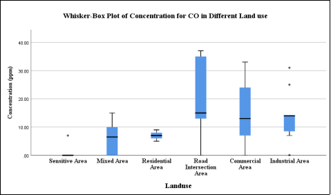
Figure 4. Whisker Box Plot of the Concentration of CO in Different Land use.
The whisker box plot shows the average CO concentrations in seven land uses in Figure 4. A horizontal black line within the box marks the median; the lower boundary of the box indicates the 25th percentile, the upper boundary of the box indicates the 75th percentile. The whisker represents the maximum (upper whisker) and minimum value (lower whisker) for each land use. Points above the whiskers indicate outliers. Following whisker box plot of CO revealed that the road intersection area had higher dispersion followed by commercial area with positively skewed values. The moderate distribution was seen in industrial area with two outliers. This outlier was found outside of Mita Oil & Food Industries and A. R. Specialized Auto Rice Mills area due to industrial activities. The residential area had less moderate distribution with normally skewed distribution. The sensitive area had the most clustered concentration with one outlier; the situation was found outside of APS Office due to sudden movements of vehicles.
3.5. Land Use Based Cluster Analysis
Figure 5(a) illustrates the dendrogram plot obtained from cluster analysis in terms of PM1 with Z-score normalization. For this analysis average linkage between groups has been considered. Three clusters have been found from the graph below. First cluster consists of residential area, industrial area and sensitive area; second cluster includes mixed area and commercial area; and third cluster includes road intersection area alone. First and second cluster join at the approximate distance of 10 which joins with third cluster the approximate distance of 25.
Figure 5(b) shows the dendrogram plot obtained from cluster analysis in terms of PM2.5 with Z-score normalization. For this analysis average linkage between groups has been considered. Three clusters have been found from the graph below. First cluster consists of residential area, industrial area and sensitive area; second cluster includes mixed area and commercial area; and third cluster includes road intersection area alone. First and second cluster joins at the approximate distance of 9 which joins with third cluster the approximate distance of 25. Figure 5(c) shows the dendrogram plot obtained from cluster analysis in terms of PM10 with Z-score normalization. For this analysis average linkage between groups has been considered. Three clusters have been found from the graph below. First cluster consists of residential area, industrial area and sensitive area; second cluster includes mixed area and commercial area; and third cluster includes road intersection area alone. First and second cluster joins at the approximate distance of 8 which joins with third cluster the approximate distance of 25. Figure 5(d) shows the dendrogram plot obtained from cluster analysis in terms of CO with Z-score normalization. For this analysis, group linkage and Euclidean distance have been considered. Four clusters have been found from the graph below. First cluster consists of residential area and mixed area; second cluster includes sensitive area only; third cluster includes commercial area and industrial area; and forth cluster includes the road intersection area alone. First and second cluster joins with third cluster at the distance of 7 which joins with forth cluster the approximate distance of 25.
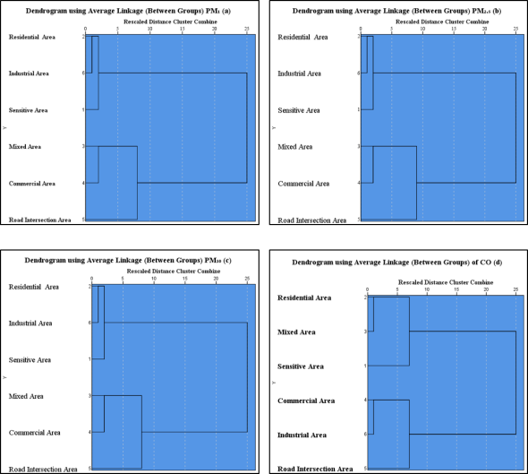
Figure 5. Land Use Based Cluster Analysis of PM1, PM2.5, PM10 and CO.
3.6. Comparison Among Average Concentration of PM1, PM2.5 & PM10 of Different Land Use
The Figure 6 illustrates the comparison of the average concentration of PM1, PM2.5 & PM10 of seven lands uses in Pabna district town. The average concentration of PM1, PM2.5 & PM10 was higher in the road intersection area, commercial area and mixed area with the values of 45.85, 76.60 and 98.10 µg/m3; 40.63, 65.88 and 85.71 µg/m3 and 36.83, 60.75 and 78.29 µg/m3 respectively with highest in the road intersection area. It was also observed that the concentrations of PM2.5 and PM10 found in the most polluted land use were 3.06 and 1.95 times higher than World Health Organization (WHO) which are 25 and 50 µg/m3 respectively. The concentration of PM was found relatively lower in sensitive area, residential area and industrial area. Moreover, the average concentration of PM1 (25.64 µg/m3), PM2.5 (42.61 µg/m3) and PM10 (54.58 µg/m3) were found to be least in sensitive area.
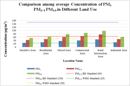
Figure 6. Comparison among Average Concentration of PM1, PM2.5 & PM10.
3.7. Three (3) Most and Least Polluted Locations in 40 Locations of Pabna District Town
Table 5. Three (3) Most and Least Polluted Locations.

Rank

Land use Type

Land Use

PM1

PM2.5

PM10

Road Intersection Area

Chadmari Moor

78.25

132.25

169

Commercial Area

Tula Potti

54

85.5

112.25

Mixed Area

Pabna Medical College

51.25

85

108.75

Sensitive Area

Chief Judicial Magistrate Court

14.75

25

32

Mixed Area

Public Library Pabna

18.75

33

41.75

Sensitive Area

Onukul Chandra Shotshonggo

22.75

36.75

47.75

According to the concentration (µg/m3) of PM1, PM2.5 & PM10 among 40 locations, 3 most polluted places were Chadmari Moor (Road Intersection Area), Tula Potti (Commercial Area) and Pabna Medical College (Mixed Area) and 3 least contaminated places were Chief Judicial Magistrate Court, Public Library Pabna and Onukul Chandra Shotshonggo (Table 5). It has been observed that concentrations of PM1, PM2.5 & PM10 of Chadmari Moor and Chief Judicial Magistrate Court were 78.25, 132.25 and 169 µg/m3 and 14.75, 25 and 32 µg/m3 respectively. It was also noted that the concentrations of PM2.5 and PM10 found in the most polluted location were 5.29 and 3.38 times higher than World Health Organization (WHO) which are 25 and 50 µg/m3 respectively.
3.8. Concentration Map on PM1, PM2.5, PM10 and CO
Figure 7 show the concentration of Particulate Matter (PM1, PM2.5, PM10) and CO at various location of Pabna district town in the year of 2021. Concentrations of Particulate Matter (PM1) are expressed in µg/m3. The concentration of µg/m3 means one-millionth of a gram of PM1 per cubic meter of air. Yellow areas have less, while progressively higher concentrations are shown in orange and red. The concentration of PM1 was found to higher (50-40.2 µg/m3) in some part of Pabna Sadar Upazila, Sujanagor Upazila, Bera Upazila. The maximum concentration shows with blue point and minimum concentration with green point. The top maximum concentration was found in Chadmari Moor and the least concentration was found in Chief Judicial Magistrate Court. Concentrations of Particulate Matter (PM2.5) are expressed in µg/m3. The concentration of µg/m3 means one-millionth of a gram of PM2.5 per cubic meter of air. Yellow areas have little, while progressively higher concentrations are shown in orange and red. The concentration of PM2.5 was found to higher (83.8-67.5 µg/m3) in some part of Pabna Sadar Upazila, Atgaria Upazial and Chatmohar Upazila. The maximum concentration shows with red flag and minimum concentration with green flag. The top maximum concentration was found in Chadmari Moor and the least concentration was found in Chief Judicial Magistrate Court. Concentrations of Particulate Matter (PM10) are expressed in µg/m3. The concentration of µg/m3 means one-millionth of a gram of PM10 per cubic meter of air. Yellow areas have little, while progressively higher concentrations are shown in orange and red. The concentration of PM2.5 was found to higher (107-79.3 µg/m3) in the part of Sujanagar Upazila, Atgaria Upazila, Pabna Sadar Upazila. The maximum concentration shows with blue point and minimum concentration with green point. The top maximum concentration was found in Chadmari Moor and the least concentration was found in Chief Judicial Magistrate Court. Concentrations of carbon monoxide are expressed in parts per million by volume (ppm). A concentration of 1 ppm means that for every million molecules of gas in the measured volume, one of them is a carbon monoxide molecule. Yellow areas have little or no carbon monoxide, while progressively higher concentrations are shown in orange and red. The concentration of CO was found to higher (22.8-16.2 µg/m3) in the Bera Upazila, Sujanagar Upazila, Faridpur Upazila, Santhia Upazila. The maximum concentration shows with blue point and minimum concentration with green point. The top maximum concentration was found in Chadmari Moor and the least concentration was found in Chief Judicial Magistrate Court.
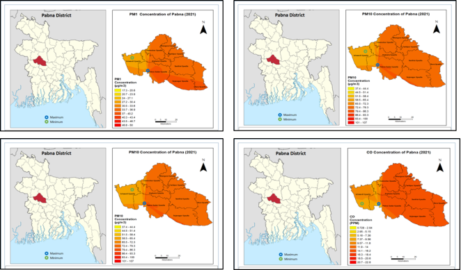
Figure 7. PM1, PM2.5, PM10 and CO Concentration of Pabna District Town.
4. Conclusion
Study found that the average concentration of PM1, PM2.5 & PM10 of 41 places in Pabna district town were 34.50, 57.02 and 73.43 µg/m3 respectively. From the outcome of this research the studied land uses are arranged in descending order based on average concentration PM which follows road intersection area > commercial area > mixed area > village area > industrial area > residential area > sensitive area. The Concentration of PM2.5 and PM10 were found 2.28 and 1.49 times higher than the standard level. Moreover, it was estimated from the average ratio of PM2.5 /PM10 showed that the PM2.5 mass was 77.63%of the PM10 mass and the average ratio PM1 /PM2.5 showed that the PM1 mass was 60.46% of the PM2.5 mass. It is further found that, the changes in the concentration of PM and CO do not change significantly since the p value is greater than 0.05. From the dendrogram plot of PM1, PM2.5, PM10 it has been found out that each of the analysis included at least four clusters at the first phase and these were consecutively to make a single cluster at the approximate distance of 25.
5. Limitation of the Study
To
Abbreviations

ECA

Energy and Clean Air

DoE

Department of Environment, Bangladesh

NAAQS

National Ambient Air Quality Standard

PM

Particulate Matter

UNEP

United Nations Environment Programme

U.S. EPA

U. S. Environmental Protection Agency

WHO

World Health Organization

Author Contributions
Ahmad Kamruzzaman Majumder: Conceptualization, Data curation, Formal Analysis, Investigation, Methodology, Project administration, Resources, Software, Supervision, Validation, Visualization, Writing - original draft, Writing - review & editing
Mohammad Tariq Ali: Conceptualization, Data curation, Formal Analysis, Investigation, Methodology, Funding, Resources, Software, Validation, Writing - original draft, Writing - review & editing
Conflicts of Interest
The authors declare no conflicts of interest.
References
[1] WHO- World Health Organization (2024). Air pollution. Retrieved August 25, 2024, from
[2] NRDC - Natural Resources Defense Council (2024). Clean air. Natural Resources Defense Council. Retrieved August 27, 2024, from
[3] UNEP - United Nations Environment Programme (2023). Air Pollution Note: Data You Need to Know. UNEP. Retrieved August 27, 2024, from
[4] World Bank (2022ᵃ). Fighting air pollution: A deadly killer and core development challenge. World Bank. Retrieved August 27, 2024, from
[5] AQLI - Air Quality Life Index. (2023). AQLI top charts 2023. The University of Chicago, Energy Policy Institute. Retrieved from
[6] UNICEF (2024). Disease burden of air pollution on children continues to rise in Bangladesh, according to latest report. UNICEF. Retrieved from
[7] World Bank. (2022ᵇ). Bangladesh clean air and sustainable environment project implementation completion and results report (Report No. P168901). World Bank. Retrieved from
[8] U. S. EPA - U. S. Environmental Protection Agency (2024ᵃ). Particulate matter (PM) basics. Retrieved August 25, 2024, from
[9] IQAir (2023). World Air Quality Report 2023. IQAir. Retrieved from
[10] Thangavel, P., Park, D. and Lee, Y. (2022). Recent Insights into Particulate Matter (PM2.5)-Mediated Toxicity in Humans: An Overview. Int J Environ Res Public Health, 19(12), 7511.
[11] HEI - Health Effects Institute (2024). State of global air report 2024. Health Effects Institute. Retrieved August 27, 2024, from
[12] EIU - Economist Intelligence Unit (2024). The global liveability index 2024: Summary report. Economist Intelligence Unit. Retrieved August 27, 2024, from
[13] Majumder, A. K., Hossain, S. M. A., Patoary, M. N. A., & Rahman, M. (2023). Spatial distribution of air quality in Netrokona district town, Bangladesh. Open Access Research Journal of Engineering and Technology, 5(1), 1-11.
[14] Majumder, A. K., Mahmud, K. K., Rahman, M., Patoary, M. N. A., Gautam, S., and Tanima, K. R. (2025). Spatial distribution and health implications of particulate matter concentrations across diverse land use types in Dinajpur District, Bangladesh. Geosystems and Geoenvironment, 4(3), 100397, ISSN 2772-8838.
[15] Majumder, A. K., Rahman, M., Patoary, M. N. A., Kamruzzaman, A. M. and Majumder, R. (2024ᵃ). Time Series Analysis PM2.5 Concentration for Capital City Dhaka from 2016 to 2023. Science Frontiers, 5(1): 35-42.
[16] Majumder, A. K., Akbar, A. T. M. M., Rahman, M., Patoary, M. N. A., Islam, M. R., and Majumder, R. (2024ᵇ). Monsoon Season Spatial Distribution of Particulates Concentration in the Road Intersection Area of Different Land Use in Major City in South Asian Countries. Journal of Health and Environmental Research, 10(1): 15-28.
[17] Dibya, T. B., Proma, A. Y. and Dewan, S. M. R. (2023). Poor Respiratory Health is a Consequence of Dhaka’s Polluted Air: A Bangladeshi Perspective. Environ Health Insights, 17: 11786302231206126.
[18] Pabna District - Banglapedia. (2025).
Cite This Article
  • APA Style

    Majumder, A. K., Ali, M. T. (2025). Urban Land Use and Particulate Matter Distribution During Winter: A Case Study of Pabna District Town, Bangladesh. Journal of Health and Environmental Research, 11(3), 76-88. https://doi.org/10.11648/j.jher.20251103.14

    Copy | Download

    ACS Style

    Majumder, A. K.; Ali, M. T. Urban Land Use and Particulate Matter Distribution During Winter: A Case Study of Pabna District Town, Bangladesh. J. Health Environ. Res. 2025, 11(3), 76-88. doi: 10.11648/j.jher.20251103.14

    Copy | Download

    AMA Style

    Majumder AK, Ali MT. Urban Land Use and Particulate Matter Distribution During Winter: A Case Study of Pabna District Town, Bangladesh. J Health Environ Res. 2025;11(3):76-88. doi: 10.11648/j.jher.20251103.14

    Copy | Download

  • @article{10.11648/j.jher.20251103.14,
      author = {Ahmad Kamruzzaman Majumder and Mohammad Tariq Ali},
      title = {Urban Land Use and Particulate Matter Distribution During Winter: A Case Study of Pabna District Town, Bangladesh
    },
      journal = {Journal of Health and Environmental Research},
      volume = {11},
      number = {3},
      pages = {76-88},
      doi = {10.11648/j.jher.20251103.14},
      url = {https://doi.org/10.11648/j.jher.20251103.14},
      eprint = {https://article.sciencepublishinggroup.com/pdf/10.11648.j.jher.20251103.14},
      abstract = {Air pollution is a major public health concern in Bangladesh, contributing to significant respiratory and cardiovascular issues. The objective of this study is to monitor the Particulate Matters (PM1, PM2.5 & PM10) and Carbon Monoxide (CO) concentration based on different land use in Pabna district town. This study was conducted in 40 locations of Pabna district town, by using portable Air Quality Monitor, Indoor Outdoor Formaldehyde (HCHO) Detector (Model: DM106) and CO Meter (Model: AS8700A). It was found that, the average concentrations of PM1, PM2.5 & PM10 of 40 places in Pabna district town were 34.50, 57.02 and 73.43 µg/m3 respectively. The average concentration of PM2.5 and PM10 were found 2.28 and 1.49 times higher than World Health Organization (WHO) which is respectively. It is estimated that the average PM2.5 /PM10 was 77.63%, PM1 /PM2.5 was 60.46%. From the outcome of this research the studied land uses are arranged in descending order based on average concentration PM which follows as road intersection area > commercial area > mixed area > industrial area > residential area > sensitive area. Therefore, the findings underscore the urgent need for targeted air quality management strategies in Pabna district, particularly in high-pollution areas, to mitigate health risks associated with elevated particulate matter concentrations.
    },
     year = {2025}
    }
    

    Copy | Download

  • TY  - JOUR
    T1  - Urban Land Use and Particulate Matter Distribution During Winter: A Case Study of Pabna District Town, Bangladesh
    
    AU  - Ahmad Kamruzzaman Majumder
    AU  - Mohammad Tariq Ali
    Y1  - 2025/09/09
    PY  - 2025
    N1  - https://doi.org/10.11648/j.jher.20251103.14
    DO  - 10.11648/j.jher.20251103.14
    T2  - Journal of Health and Environmental Research
    JF  - Journal of Health and Environmental Research
    JO  - Journal of Health and Environmental Research
    SP  - 76
    EP  - 88
    PB  - Science Publishing Group
    SN  - 2472-3592
    UR  - https://doi.org/10.11648/j.jher.20251103.14
    AB  - Air pollution is a major public health concern in Bangladesh, contributing to significant respiratory and cardiovascular issues. The objective of this study is to monitor the Particulate Matters (PM1, PM2.5 & PM10) and Carbon Monoxide (CO) concentration based on different land use in Pabna district town. This study was conducted in 40 locations of Pabna district town, by using portable Air Quality Monitor, Indoor Outdoor Formaldehyde (HCHO) Detector (Model: DM106) and CO Meter (Model: AS8700A). It was found that, the average concentrations of PM1, PM2.5 & PM10 of 40 places in Pabna district town were 34.50, 57.02 and 73.43 µg/m3 respectively. The average concentration of PM2.5 and PM10 were found 2.28 and 1.49 times higher than World Health Organization (WHO) which is respectively. It is estimated that the average PM2.5 /PM10 was 77.63%, PM1 /PM2.5 was 60.46%. From the outcome of this research the studied land uses are arranged in descending order based on average concentration PM which follows as road intersection area > commercial area > mixed area > industrial area > residential area > sensitive area. Therefore, the findings underscore the urgent need for targeted air quality management strategies in Pabna district, particularly in high-pollution areas, to mitigate health risks associated with elevated particulate matter concentrations.
    
    VL  - 11
    IS  - 3
    ER  - 

    Copy | Download

Author Information
  • Department of Environmental Science, Stamford University Bangladesh, Dhaka, Bangladesh;Center for Atmospheric Pollution Studies (CAPS), Dhaka, Bangladesh

  • Department of Environmental Science, Stamford University Bangladesh, Dhaka, Bangladesh

  • Abstract
  • Keywords
  • Document Sections

    1. 1. Introduction
    2. 2. Methodology
    3. 3. Analysis of Concentration of PM1, PM2.5, PM10 and CO
    4. 4. Conclusion
    5. 5. Limitation of the Study
    Show Full Outline
  • Abbreviations
  • Author Contributions
  • Conflicts of Interest
  • References
  • Cite This Article
  • Author Information